• This is a political forum that is non-biased/non-partisan and treats every person's position on topics equally. This debate forum is not aligned to any political party. In today's politics, many ideas are split between and even within all the political parties. Often we find ourselves agreeing on one platform but some topics break our mold. We are here to discuss them in a civil political debate. If this is your first visit to our political forums, be sure to check out the RULES. Registering for debate politics is necessary before posting. Register today to participate - it's free!

Another cool New Mexican sunset

poweRob

USMC 1988-1996
DP Veteran
Joined
Sep 18, 2011
Messages
88,714
Reaction score
65,726
Location
New Mexico
Gender
Male
Political Leaning
Socialist
Bit pissed about all the damn phone lines and wires in the way but I had to hurry before it went away... This is last night on the way home.

SFsunset.webp
 
Here's a couple I took about a month ago, no phone lines. :2razz:

t2_272O4J8V2BsR7mRGwx1CxM9jIyOodQS2OnD9xiO4pX92IB.webp

FcgrFiTVvKPzI3Rw5NgSbbejAmNOfFDd7kYdPt1u_lwpX92IB.webp
 
I saw a sunset when driving home a few years back that I so regret missing taking a picture of. It was the weirdest looking thing. Just above the horizon the was a parallel line and between that line and the horizon were red streaks falling straight down. It looked like it was raining fire. It was so pretty but I couldn't find a pullover spot with a vantage fast enough before it went away. The red was the brightest, fiercest red I had ever seen in a sky.
 
I saw a sunset when driving home a few years back that I so regret missing taking a picture of. It was the weirdest looking thing. Just above the horizon the was a parallel line and between that line and the horizon were red streaks falling straight down. It looked like it was raining fire. It was so pretty but I couldn't find a pullover spot with a vantage fast enough before it went away. The red was the brightest, fiercest red I had ever seen in a sky.

We were just taking the scenic route home from a evening in Virginia City (35 miles on a dirt road over the mountain). It was so beautiful out, ran into these guys same night. Not quite as good as a photo as it was from my phone and they were moving.

9oKUXtu2RYO46XibhSmzrAKpBRO38Syqd_59I5wsoqUpX92IB.webp
 
Bit pissed about all the damn phone lines and wires in the way but I had to hurry before it went away... This is last night on the way home.


Wait.....there is a NEW Mexico?
 
This one was from the Santa Fe Opera... I posted in another thread. These two photos were just a minute or two apart. Check out the difference in color that that minute or two made.

Operasunset1.webp

Operasunset2.webp
 
Here are two from my last trip to White Sands. May be back there shortly as a side-trip to our (now) annual trip to SW CO for fall color.

11692954413_4139fbf4e8_b.webp

I only noticed the two people waaaay out there on foot after processing the image.
11907282004_ffd51783ee_b.webp
 
Here are two from my last trip to White Sands. May be back there shortly as a side-trip to our (now) annual trip to SW CO for fall color.

View attachment 67239883

I only noticed the two people waaaay out there on foot after processing the image.
View attachment 67239884
White sands is just crazy. If it weren't for the damn heat, you'd swear you were standing in snow-drifts.
 
Here are two from my last trip to White Sands. May be back there shortly as a side-trip to our (now) annual trip to SW CO for fall color.

View attachment 67239883

I only noticed the two people waaaay out there on foot after processing the image.
View attachment 67239884

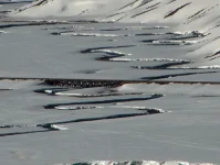
Speaking of Southern Colorado... I took this several years ago near La Munga pass I believe. It is a narrow guage track, (Silverton train rail I think) crossing a snowy stream.

snowytracks.webp

At work I end up in the field quite a bit so I catch neat things to take pictures of from time to time:

Snowshape.webp
 
Santa Fe used to be the wild wild west of course and it had boatloads of gambling establishments and whatnot. The people who lost their money at these establishments often came from this moutain just south of town. The Ortiz Mountains.

Bikiniscar.webp

This mountain was a big gold mine strike and all these miners had claims all over that mountain. They'd take their earnings into town, lose, and go back to digging. What you see in that picture is called the, "Bikini scar". As you approach the mountain from below it looks like a bikini bottom in shape. As the years went on all these miner claims got bought out bit by bit by larger, more successful miners then mining companies and so on until, like the Highlander, there was only one. They mined it all the way until the 1970's. This scar is the reclamation that they are still responsible for cleaning up because mining is hella-toxic. The road approaching this mountain is actually called Gold Mine Rd.

This pic was me in the field waaaaay up in the mountain looking down on that part. It was a bitch of a hike. We climbed I think it was 3,000 feet from elevation 6,000 to 9,000 and not on an easy trail at all. And I was definitely not in shape for it when I did it.
 
Santa Fe used to be the wild wild west of course and it had boatloads of gambling establishments and whatnot. The people who lost their money at these establishments often came from this moutain just south of town. The Ortiz Mountains.

View attachment 67239888

This mountain was a big gold mine strike and all these miners had claims all over that mountain. They'd take their earnings into town, lose, and go back to digging. What you see in that picture is called the, "Bikini scar". As you approach the mountain from below it looks like a bikini bottom in shape. As the years went on all these miner claims got bought out bit by bit by larger, more successful miners then mining companies and so on until, like the Highlander, there was only one. They mined it all the way until the 1970's. This scar is the reclamation that they are still responsible for cleaning up because mining is hella-toxic. The road approaching this mountain is actually called Gold Mine Rd.

This pic was me in the field waaaaay up in the mountain looking down on that part. It was a bitch of a hike. We climbed I think it was 3,000 feet from elevation 6,000 to 9,000 and not on an easy trail at all. And I was definitely not in shape for it when I did it.

Yeah, mining can be toxic. My son wanted me to go on an underground mine tour in Butte, which we did on Wednesday. This picture is from 100' down about 3' above the now current water level. Original mine went down 3,800'.

NrmBsqeZRj0qtd7sXr9sCrYQwYhyH8l_oSm0sGBWLBApX92IB.webp

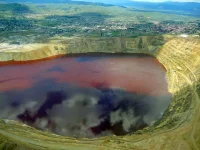
Here's the rest of the water, one of the largest superfund sites (not my pic). It's filled all the 10,000 miles of mine shafts under Butte. They are going to finally start pumping and treating the water early next year (just to maintain level)

BP_02_0.webp

https://en.wikipedia.org/wiki/Berkeley_Pit
 
I love New Mexico. Probably one of my new favorite states, and I didn't even get to stay there very long.

Did you get to the Enchanted Circle ⭕️ in NM?

The eastern overlook of Albuquerque —
 
Last edited:
Yeah, mining can be toxic. My son wanted me to go on an underground mine tour in Butte, which we did on Wednesday. This picture is from 100' down about 3' above the now current water level. Original mine went down 3,800'.

View attachment 67239889

Here's the rest of the water, one of the largest superfund sites (not my pic). It's filled all the 10,000 miles of mine shafts under Butte. They are going to finally start pumping and treating the water early next year (just to maintain level)

View attachment 67239890

https://en.wikipedia.org/wiki/Berkeley_Pit

I've heard about that nasty pit. It's actually a tourist draw isn't it? "Come look at our toxic sludge!" I hope they get it cleaned up well... if they can.

South of the City of Santa Fe, is Madrid, NM. They had a lot of mining in that area. Turquoise, silver, gold, coal (hard and soft coal side by side I'm told which is supposedly rare). It's all now just a community that is turning itself into a tourist trap. They shot the movie Wild Hogs there.
 
That should go on your license plates.

The ‘ZIA’ symbol on their license plate is my favorite. I will speak of it again to the students this afternoon.
 
Did you get to the Enchanted Circle ⭕️ in NM?

The eastern overlook of Albuquerque —

No, but Hubs and I plan on going back and spending a little more time there, and also Arizona. Too many places we wanted to see that we just missed. Most of my time in NM, while not on I-40, was on 285 from Ft. Stockton to Roswell. Now that was a trippy trip. :lol:
 
I've heard about that nasty pit. It's actually a tourist draw isn't it? "Come look at our toxic sludge!" I hope they get it cleaned up well... if they can.

South of the City of Santa Fe, is Madrid, NM. They had a lot of mining in that area. Turquoise, silver, gold, coal (hard and soft coal side by side I'm told which is supposedly rare). It's all now just a community that is turning itself into a tourist trap. They shot the movie Wild Hogs there.

yeah if I was from there, I wouldn't brag about that part.
 
I've heard about that nasty pit. It's actually a tourist draw isn't it? "Come look at our toxic sludge!" I hope they get it cleaned up well... if they can.

South of the City of Santa Fe, is Madrid, NM. They had a lot of mining in that area. Turquoise, silver, gold, coal (hard and soft coal side by side I'm told which is supposedly rare). It's all now just a community that is turning itself into a tourist trap. They shot the movie Wild Hogs there.

It will never, ever be cleaned up, just maintained. They finally have to start treating it as the water will hit the alluvial level very soon if they don't and that would be catastrophic. It is extremely acidic PH 2.5. The main challenge in the treatment is not the acidity, it's removing the cadmium and other heavy metals. The guide told us a flock of 10,000 geese landed in it last winter (alarm system was down to drive them away). 5,000 of them died overnight in the pit and unknown others flew away and died all over the place.

I live about 60 miles away, but thank god I'm on the other side of the continental divide.

Other interesting fact about the ore taken out of Butte. They took enough copper out of the mines in Butte to pave a 450 mile 4-lane highway 4" thick.
 
The ‘ZIA’ symbol on their license plate is my favorite. I will speak of it again to the students this afternoon.

Yeah it's really cool. I got it on a travel bag when I went through there. *embarrassed* Was such a tourist. Spent so much in a gift shop that they gave it to me for free.
 
That should go on your license plates.

My favorite New Mexico saying is "Carpe' Mañana".

It's a ripoff of the Latin phrase "Carpe' Diem" (Seize the day!)

Carpe' Meñana! translates into "Seize tomorrow".

Currently I own a t-shirt sporting "Carpe' Vino!"
 
Last edited:
It will never, ever be cleaned up, just maintained. They finally have to start treating it as the water will hit the alluvial level very soon if they don't and that would be catastrophic. It is extremely acidic PH 2.5. The main challenge in the treatment is not the acidity, it's removing the cadmium and other heavy metals. The guide told us a flock of 10,000 geese landed in it last winter (alarm system was down to drive them away). 5,000 of them died overnight in the pit and unknown others flew away and died all over the place.

I live about 60 miles away, but thank god I'm on the other side of the continental divide.

Other interesting fact about the ore taken out of Butte. They took enough copper out of the mines in Butte to pave a 450 mile 4-lane highway 4" thick.

Wow... that's just terrible about the geese.
 
Back
Top Bottom