- Joined
- Aug 31, 2018
- Messages
- 56,104
- Reaction score
- 24,826
More psychological projection
.
If you ever have an adult response to one of my posts you may quote me, otherwise, you are forbidden.
Peace

More psychological projection
.
Landfall was difficult to forecast because it came in at an oblique angle. A shift in track would also give the shear more or less time to decrease the intensity. Turns out it was less.
The wind station is in a sheltered marina with boats around it, further reducing what it measured. The station measured wind speed in knots, not mph.It might cut the wind down by 10% but not reduce the speed from 150 mph to below 80 mph, there is simply too much an energy difference.
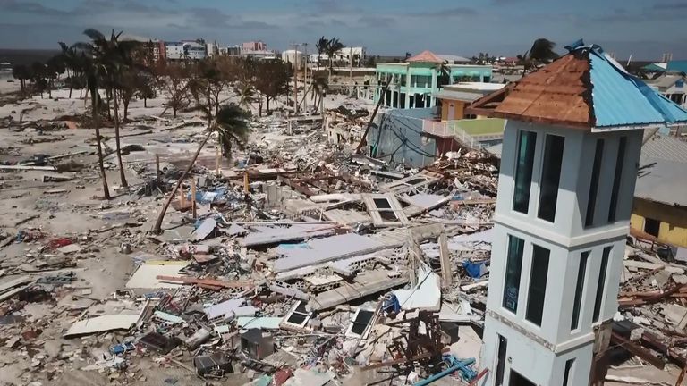
The real damage in Fort Myers beach is from storm surge.
Yes the station measured in knots, and never got gusts above 75 knots ~80 mph.The wind station is in a sheltered marina with boats around it, further reducing what it measured. The station measured wind speed in knots, not mph.
75 knots is 86mph.Yes the station measured in knots, and never got gusts above 75 knots ~80 mph.
Sorry if building and tree lines disrupted Hurricane winds that much, these storms would not be a problem beyond 10 miles inland.
The hurricane was not monitored during landfall. The advisory stating 155mph came before landfall, not at the same time. It is possible the shear began to act just before landfall as forecasted. The weather station was inland, not on the coast. It might not have measured the same windspeed as at the coast. If there was weakening prior to or at the time of landfall, that was in the forecast. The NHC did the best job they can. They worked very hard to produce the best possible forecast. They did not 'blow it.' It's not an exact science. They do what they can with what they have.
There is nothing to support any claim that the NHC purposely made an erroneous forecast. If anyone could offer anything which would improve hurricane forecasting the NHC would be glad to avail themselves of it. We are lucky to have the NHC. It is money well spent. The NHC is state of the art.
Sorry, the scale stopped at 75 knots, it looks like the peak recorded gust at Fort Myers was 69 knots , and the peak sustained wind75 knots is 86mph.
The hurricane was not monitored during landfall. The advisory stating 155mph came before landfall, not at the same time. It is possible the shear began to act just before landfall as forecasted. The weather station was inland, not on the coast. It might not have measured the same windspeed as at the coast. If there was weakening prior to or at the time of landfall, that was in the forecast. The NHC did the best job they can. They worked very hard to produce the best possible forecast. They did not 'blow it.' It's not an exact science. They do what they can with what they have.
There is nothing to support any claim that the NHC purposely made an erroneous forecast. If anyone could offer anything which would improve hurricane forecasting the NHC would be glad to avail themselves of it. We are lucky to have the NHC. It is money well spent. The NHC is state of the art.


No it didn't. Why make up lies?Then get knocked down to a one. Good ****in grief. Are you even serious?
Mar a Lago is on the opposite coast and nowhere near the Hurricane
126 mph wind recorded at Redfish pass. Eek.
Fort Myers is devastated.
Can you cite what source made this measurement?126 mph wind recorded at Redfish pass. Eek.
Fort Myers is devastated.
I only ask because I found this, which indicates the 126 mph was the gust speed not the sustained wind speed.126 mph wind recorded at Redfish pass. Eek.
Fort Myers is devastated.
Special Notes
A River, Estuary, and Coastal Network station at Redfish Pass, Florida, recently reported sustained winds of 94 mph and a wind gust of 126 mph, while a Weatherflow station near Sanibel Island, Florida, recently reported sustained winds of 83 mph and a wind gust of 107 mph.
Sorry, the scale stopped at 75 knots, it looks like the peak recorded gust at Fort Myers was 69 knots , and the peak sustained wind
was a little less than 50 knots. 69 knots is 79 mph, but that is a gust, sustained winds were 57.5 mph.
I am not sure you understand what I am saying, structures and trees do not drop the wind speed in half.
They will cause a small drop, but not a drop from 150 mph sustained to 57.5 mph.
We are not talking about forecast, but actual measured wind speeds.
I am looking for readings from port Charlette,
View attachment 67415616
I did find this, but it seems to say what I am seeing, they estimated the wind at 145 mph, but the actual measured sustained wind was at 85 mph.
View attachment 67415619
The dense wall of thunderstorms surrounding the eye has the strongest winds within the storm. Changes in the structure of the eye and eyewall can cause changes in the wind speed, which is an indicator of the storm's intensity. The eye can grow or shrink in size, and double (concentric) eyewalls can form.
Can you cite what source made this measurement?
Observing the linked radar video loop of the landfall shows a break in the feeder bands just as the eyewall reaches the coast of Captiva Island. Redfish Pass is located at the North tip. Captiva Island is North of Sanibel Island.I only ask because I found this, which indicates the 126 mph was the gust speed not the sustained wind speed.
Hurricane Ian Made Landfall On Captiva Florida: Doppler Radar And Amazing Surge Video
Did you see the notice from redfish island about sustained wind speeds?That assessment would be based on the incorrect assumption that the hurricane is perfect and that the maximum winds occur uniformly around the eye at all times and in all quadrants.
That is not true. The maximum winds do not surround all parts of the eye at all times.
The eye is formed by the feeder rain bands rotating inward. The flow then goes upward in a swirl, and out at the top. It is not uniform. The maximum winds occur in the rain feeder bands near the eyewall where they are most compressed. Other parts of the eye wall have lower winds.
Fort Myers got the southern drier part of the eye. That could explain why the maximum recorded winds at Fort Myers station do not match the maximum winds of the hurricane.
I thank you for your persistence in this, and it certainly did raise a quandry of why Fort Myers station did not see greater winds. I had to do some research and learning to answer that question, and it has been educational. I enjoyed learning more about hurricanes. I hope this answers the question for you and shows that no, the NHC did not 'blow the forecast.'
Hurricane Structure
Did you happen to read it?I saw the report, too.
Coastal Network Station Redfish Pass is down. Perhaps it got destroyed. This link says 'unavailable.'
The gust speed is not the maximum sustained wind speed!Observing the linked radar video loop of the landfall shows a break in the feeder bands just as the eyewall reaches the coast of Captiva Island. Redfish Pass is located at the North tip. Captiva Island is North of Sanibel Island.
It also can be seen that the feeder bands going over Fort Myers are not as dense as the ones to the North of the eye.
Dense feeder bands near the eye contain the maximum winds. Not so dense feeder bands contain lower wind speeds. Lack of feeder bands areas contain even lower wind speeds.
Do you think hurricanes are perfectly formed, with uniform winds at the maximum windspeed surrounding the eyewall in all quadrants?The gust speed is not the maximum sustained wind speed!
Yes.Did you see the notice from redfish island about sustained wind speeds?
Yes storm surge is devastating, water is much denser than air!Fort Myers Beach
All the readings I have found have the sustained winds below 80 mph, the high speeds look like estimates and gust speeds.Yes.
Maximum winds are not uniform around the eye. What is your response to post 214?