- Joined
- Mar 6, 2019
- Messages
- 26,084
- Reaction score
- 23,716
- Location
- PNW
- Gender
- Male
- Political Leaning
- Other
I've been in a number of discussions regarding the divergence of "Red" and "Blue" America, here and elsewhere. Just this week, the leak of the Dobbs draft opinion has reinvigorated the debate.
As with just about every current issue, there is a stark divergence of opinion between "conservative" America, and "liberal" America. But, having studied the circumstances, this is really a matter of geography and demographics as much as politics, and that is why it is such a tough nut to crack. I agree with the conclusion that the divide is about to get starker, but there is so much to it. In a 2020 study, UNLV produced
Blue Metros, Red States: America's Suburbs and the New Battleground in Presidential Politics (UNLV).
From the latter, there is this graphic
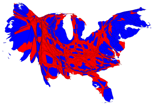
I know it looks weird, but it illustrates just how intransigent the issue is. What it represents is where the Republican and Democratic votes are, and their relative strength. Blue States have large conservative voting blocks, and even in the Reddest of Red States (with a few exceptions), there are large bastions of Democratic voters - Bozeman, Montana; Austin and Houston, Texas; Memphis and Nashville, Tennessee; Kansas City and St. Louis, Missouri. What is also points out is, Red State, Blue City: How the Urban-Rural Divide Is Splitting America (Atlantic).
Given that, how do we divvy up the country? "Partisan lines that once fell along regional borders can increasingly be found at the county level. What does that mean for the future of the United States?"
Even in my county and State, the rural/urban divide is pretty profound. In Washington, 3/4 of the population lives along the I-5 corridor, but that represents only 1/3 of the State's geography. East Pierce and King County doesn't resemble the West side (where Tacoma and Seattle are) at all. The 2020 election results are instructive: Joe Biden won Washington 58.4% to 39 percent, but only 10 of 39 counties. The same trend applies all over the country. "The difference is no longer about where people live, it's about how people live: in spread-out, open, low-density privacy -- or amid rough-and-tumble, in-your-face population density and diverse communities that enforce a lower-common denominator of tolerance among inhabitants.
The voting data suggest that people don't make cities liberal -- cities make people liberal."
What Dobbs will potentially bring to the fore is the vicious and visceral divide between politicians and their constituents, and between the rural, urban, suburban and exurban areas. People are going to feel trapped in foreign territory, no matter which side of the divide they reside on.
America’s Blue-Red Divide Is About to Get Starker (Atlantic)
"As abortion rights are rolled back in certain states, the gap between the country’s two dominant political coalitions will widen."As with just about every current issue, there is a stark divergence of opinion between "conservative" America, and "liberal" America. But, having studied the circumstances, this is really a matter of geography and demographics as much as politics, and that is why it is such a tough nut to crack. I agree with the conclusion that the divide is about to get starker, but there is so much to it. In a 2020 study, UNLV produced
Blue Metros, Red States: America's Suburbs and the New Battleground in Presidential Politics (UNLV).
From the latter, there is this graphic
I know it looks weird, but it illustrates just how intransigent the issue is. What it represents is where the Republican and Democratic votes are, and their relative strength. Blue States have large conservative voting blocks, and even in the Reddest of Red States (with a few exceptions), there are large bastions of Democratic voters - Bozeman, Montana; Austin and Houston, Texas; Memphis and Nashville, Tennessee; Kansas City and St. Louis, Missouri. What is also points out is, Red State, Blue City: How the Urban-Rural Divide Is Splitting America (Atlantic).
Given that, how do we divvy up the country? "Partisan lines that once fell along regional borders can increasingly be found at the county level. What does that mean for the future of the United States?"
Even in my county and State, the rural/urban divide is pretty profound. In Washington, 3/4 of the population lives along the I-5 corridor, but that represents only 1/3 of the State's geography. East Pierce and King County doesn't resemble the West side (where Tacoma and Seattle are) at all. The 2020 election results are instructive: Joe Biden won Washington 58.4% to 39 percent, but only 10 of 39 counties. The same trend applies all over the country. "The difference is no longer about where people live, it's about how people live: in spread-out, open, low-density privacy -- or amid rough-and-tumble, in-your-face population density and diverse communities that enforce a lower-common denominator of tolerance among inhabitants.
The voting data suggest that people don't make cities liberal -- cities make people liberal."
What Dobbs will potentially bring to the fore is the vicious and visceral divide between politicians and their constituents, and between the rural, urban, suburban and exurban areas. People are going to feel trapped in foreign territory, no matter which side of the divide they reside on.